
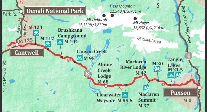
The Denali Highway
Follow along as I reminisce about my favorite road in Alaska.


The first time I crested Maclaren Summit on the Denali Highway, I felt a visceral connection to the land. Complete silence enveloped me—the kind of silence that makes your ears search for sound. Standing at 4,086 feet with the vast Maclaren River Valley stretched before me, I felt part of the earth. Even after fifteen years of touring Alaska, this remote stretch of road still takes my breath away every time I drive it.
As a self-proclaimed transport nerd—yes, I'm the kind of person who gets excited about Roman roads and railway histories—I should be focused on the engineering marvel of building a highway on permafrost. Instead, I find myself captivated by the landscape's beauty and the whispers of history that echo across it.
When what is now Denali National Park was created in 1917, the only way to reach it was to fly or brave a winter dog sled journey. In 1923, the railroad arrived, allowing people to travel by train. After World War II, Alaska's residents petitioned for road access to the park.
The term "highway" might evoke images of a major thoroughfare, but the Denali Highway defies expectations. This modest two-lane, mostly gravel road first opened to travelers in 1957. Its construction proceeded in stages from both ends, primarily to transport supplies for bridge construction over the Maclaren and Susitna Rivers. The final link connected these two waterways, with much of the bridge work accomplished during winter months atop the frozen rivers, a trick learned by the Army Corp of Engineers when building the Alcan Highway during World War II.
The journey begins in the west at Cantwell, a town whose existence is intertwined with the railroad. When the iron horse arrived in 1923, this area was accessible only by dog-sled team. Cantwell was a flag stop on the Alaska railroad named for an Irish-American officer who had led the coastguard in Alaska.
During World War II, while Rosie the Riveter became an icon in the Lower 48, local Athabascan women took charge of the railroad yard operations in Cantwell when the men departed for war. Their work demanded intense physical labor in harsh conditions. To move iron rails, these women worked in coordinated teams, chanting songs to maintain rhythm as they threw their full body weight into a specialized lever called a gandy—earning them the whimsical title of "gandy dancers."
Alice Norton, Grace Secondchief, and their fellow gandy dancers earned recognition from the government for their vital contribution to the war effort. Sometimes, when the wind howls through the valley, I imagine I hear them chanting on the wind, their voices carried through time.
Leaving Cantwell behind, the real adventure begins as the pavement ends after just three miles. The crunch of gravel beneath my tires marks my favorite transition in Alaska—the moment when cell service disappears, and the journey truly begins.

Just beyond the first ridge, on one memorable trip, I stoppped near Brushkana Campground where a momma moose and her calf stood alongside the road. They were so close I could hear the calf's breathing as it steadied itself on spindly legs, its small body dwarfed by its mother's massive frame. I could see the mother's breath in the chilly morning air. Moose calves grow remarkably quickly, as much as 2 pounds per day, and can weigh 300 pounds by autumn. But in that moment, with morning mist still clinging to the valley, this one seemed impossibly fragile.
As the sun climbs higher, I often look across to see a float plane sitting on a lake that mirrors the endless Alaskan sky. The distant drone of its engine occasionally breaks the silence as I approach my first stop of the day.
The historic Gracious House emerges like a mirage on the horizon. Still standing today, under a different name, this roadhouse was established by Mark and Mary Gatias as a haven for travelers. While Mark attended to vehicles and flat tires, Mary nourished weary travelers with hearty meals and her legendary pies.
"This used my mother’s pie crust recipe," Mary once told me, sliding a slice of blueberry pie across the counter. "I use blueberries for the filling. It’s been in the family for generations"
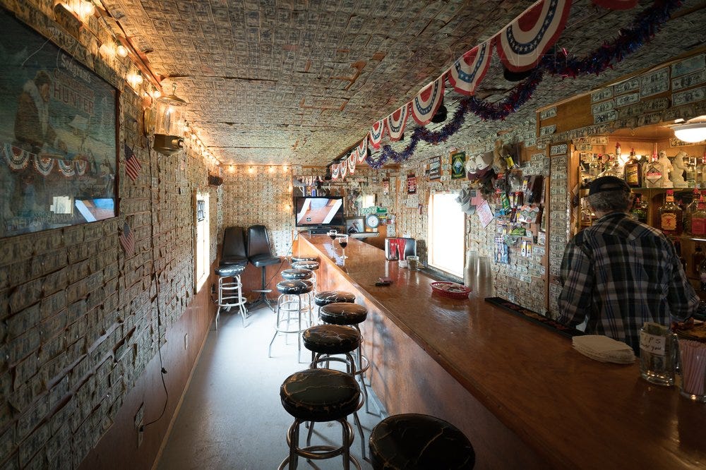
Near the parking area stood a weather-worn Quonset hut dubbed The Sluice Box. This bar had atmosphere you could almost touch—its low ceiling adorned with dollar bills bearing visitors' names and origins, the wooden floor polished by decades of boots and stories. I typically arrive around 10:30am for the much-needed bathrooms, and there's time for a Bloody Mary or a slice of the famous house pie, its crust flaky and perfect.
The modern history of this region began roughly a century ago. Gold miners in the Valdez Creek region, near the Susitna River, forged trails eastward to Paxson and westward toward present-day Cantwell. Today's highway largely follows these pioneers' paths. There is normally no traffic on this route; I expect to see only one or two vehicles during the six-hour drive. The solitude becomes a companion of its own.
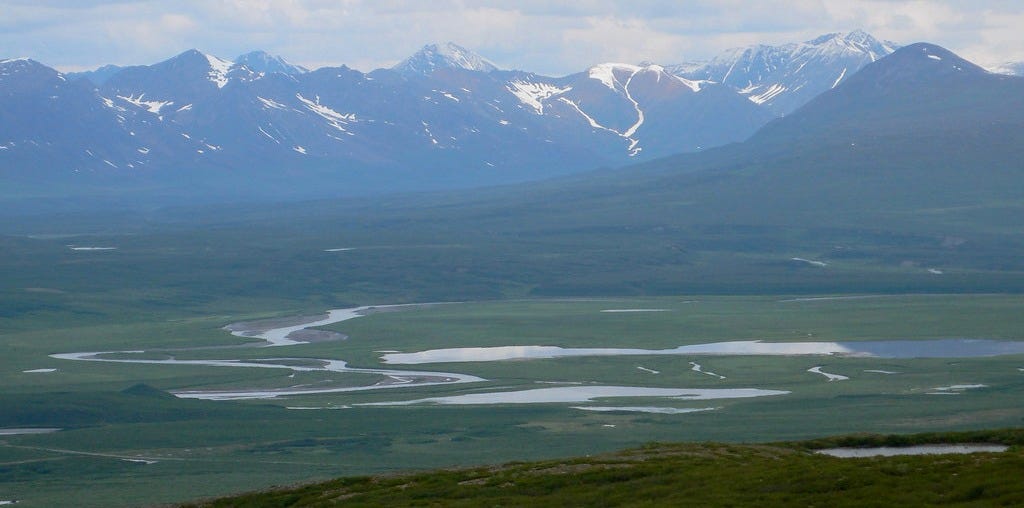
The Susitna River Bridge is one of my favorite places on the drive. I like to get out and walk across the bridge, the metal deck vibrating slightly underfoot with each step. From its steel span, I watch the braided channels below weave like silver ribbons through the valley, creating a landscape that pulses with life.
The river transforms with each passing season, making it a challenge for boat navigation, with sandbars appearing and disappearing.The engineers who built this bridge faced more than the usual challenges of distance and weather—they were attempting to traverse a living, changing entity.
During fishing season, the sandbars below often host determined anglers who set up camp, reminding me of how these waters have always fed humans.
The pathway ascends an esker or ridge formed by an ancient underground river when this area was fully glaciated during the last ice age. The vegetation changes with every hundred feet of elevation. Crazy Notch serves as a dramatic prelude to the view ahead. This distinctive geological formation emerged from the ancient movements of the Maclaren Glacier, which carved through this valley, depositing lateral moraines on both sides. A glacial stream later cut through these deposits, creating the notch that now serves as a natural snow trap, occasionally closing the highway with massive drifts during winter months.
As the road climbs through the moraine, the landscape unfolds like chapters in an ancient book. The air grows thinner, crisper, carrying the faint scent of alpine flowers. From this elevated vantage point, the magnificence of Mt Deborah, and Mt Hayes tower over the landscape. I can see the Maclaren River Valley stretching before me, with Maclaren Lodge standing sentinel on the riverbank. The river traces its path backward into the distance until, on clear days, the white and blue expanse of the Maclaren Glacier becomes visible—a frozen river that has sculpted this landscape for millennia.
Maclaren Lodge appears just when the sense of isolation reaches its peak, when I've driven far enough to wonder if I've somehow entered another world. This refuge at the highway's intersection with the Maclaren River is run by Alan and Susie and is an institution in the interior of Alaska. It is the destination for many travelers on this route in summer and in winter when snow-machine groups keep the place busy.
"How far did you come today?" Alan always asks, though he knows perfectly well where I started. It's his way of acknowledging the effort it takes to reach this place.
This is my regular lunch stop, where I see Alan and have a chat that invariably begins with the weather and ends with fishing stories. I sit by the pool table and eat my sandwich and soup, the windows framing a view that no five-star restaurant could match.
The soup is always good, the sandwiches simple. Out here, in the bush a long way from grocery stores, when you order your sandwiches, if you don't need onion or tomato or lettuce, it makes a difference. It's 240 miles each way to a grocery store from here—a fact that makes every fresh ingredient a small miracle.
After lunch there's time for a walk around, down to the bridge for a photo, time to play with the lodge dogs, or even a quick game of pool if I'm feeling sharp. Then it's back on the road, the gravel crunching as I head over the bridge and up the ridge toward Maclaren Summit. With each curve, the valley opens wider below me, until I can see for what feels like a hundred miles in every direction.
Maclaren Summit, at 4,086 feet the second-highest highway pass in Alaska, offers an amazing view across the vast expanse of the Maclaren River Valley. When I stand here with the wind whipping around me, I feel a profound connection to every traveler who has paused here: from Indigenous hunters who first blazed these trails, to gold-fevered prospectors chasing their dreams, to today's adventurers. Time is narrow in places like this, where the view has remained largely unchanged for thousands of years.
Beavers are busy at work here, and I see a large beaver lodge in a nearby lake. The beaver has built a dam to create a still pond, the water's surface occasionally broken by a sleek head or the slap of a broad tail. Like humans, beavers reshape their environment to create conditions favorable to themselves.
Because there are no trees in this landscape of tundra, the beaver has built their dam using only grass and mud, requiring constant maintenance. I've watched these tiny architects swimming back and forth, carrying mouthfuls of grasses to patch their structures.
The permafrost landscape alongside the highway showcases the construction techniques learned during the building of the Alcan Highway. This route will remain gravel due to the underlying glacial substructure. One of my favorite activities is to stop and explore the tundra on foot, placing my bare hand against the permafrost to feel its ancient chill just inches below the surface's summer warmth.
In season, wild blueberries dot the landscape, offering sweet rewards for only a few minutes' work. Their tart sweetness bursts in my mouth, tasting nothing like their cultivated cousins in grocery stores.
Just around the next bend lies one of Alaska's most magnificent geological features. Landmark Gap presents itself as a masterpiece of glacial architecture—a perfect U-shaped valley carved by ice age forces. Its walls tower hundreds of feet high, testament to the massive glaciers that once shaped this landscape. In autumn, caribou migrate through this corridor, sometimes in vast herds that darken the valley floor. I've watched these creatures follow paths worn into the tundra over millennia, the soft clicking of their hooves carried on the still air. Their ancient patterns remind me of the pattern of my life.
The Tangle Lakes Archaeological District preserves stories of hunters who observed these same migrations 10,000 years ago. This 225,000-acre district, listed on the National Register of Historic Places, contains some of North America's earliest evidence of human occupation, with over 400 documented archaeological sites providing windows into this continent's distant past.
Here, evidence has been found of walls built to funnel the migrating caribou into killing areas where, armed with spears, these hunters would feed their families. From the earliest Americans to the Ahtna Athabascan peoples of the Copper River Basin, the Tangle Lakes area has served as crucial seasonal hunting grounds. Walking across this landscape, I sometimes find myself pausing to pick up a stone, wondering if it might have been touched by human hands thousands of years ago.
Modern hunters still frequent this area, for the same reason. This thoroughfare is almost deserted most of the year; the exception is September, hunting season, when you will see many vehicles and hunting camps crop up all along the way. The scent of wood smoke drifts across the tundra, and occasionally the sharp report of a rifle echoes through the valleys.
When I see people out enjoying the landscape today—hunting, fishing, or hiking—I think about the Athabascan people who were here before and lived in this landscape using just the tools of the environment around them. The Athabascans strive to keep their culture and traditions alive, maintaining a connection to this land that runs deeper than any highway ever could.
The pavement has returned but that is not really an improvement; the skin of the road is buckled with frost heaves. Time to slow down and enjoy weaving through the lakes and glacial erratics at the pace of a slow walk.
The Gulkana Glacier appears as a frozen river of time, its medial moraine drawing a dark line across the ice that speaks to geological forces beyond human comprehension. The Gulkana river valley opens below me, the silver thread of the Trans Alaska pipeline elevated to protect the fragile permafrost environment. Another perfect picture stop where you can never capture the feeling of being surrounded by such immensity.
The journey's finale unfolds as a magnificent crescendo. Mt. Wrangell dominates the horizon, a vast active shield volcano, named for the Russian governor of Alaska. On cold days, the steam from its crater is visible, a reminder that beneath the snow and ice, the earth remains alive and restless. Drum and Sanford pierce the clouds, their snow-crowned summits commanding attention even from those who have seen the world's great mountain ranges.
By the time I reach Paxson, 135 miles from my starting point in Cantwell, I've been transformed by the essence of the Denali Highway—it's not merely a road, but a passage through time that grounds me in the world. In autumn, when the tundra ignites with color and caribou move like shadows across the land, this truth is undeniable.
Each traverse of this remote ribbon of gravel serves as a thread connecting me to something greater than myself, a reminder that in Alaska, the wild heart of the land continues to beat strong and true.
Hey Micheal, I ran cross country adventure tours up there for a couple seasons. I believe I once stayed at the Tangle Lakes Lodge. It was a long time ago. Did you ever drive up the Cassiar and meet Mighty Moe?
Really enjoyed the journey, feels like I am doing the trip myself. Great writing!!